
The Pothole Problem: What If the Bin Lorry Inspected Your Road Every Week?
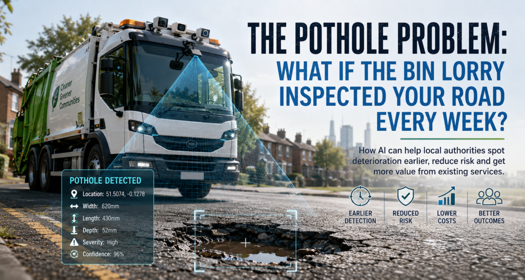
How vehicles already travelling Britain’s roads could help local authorities spot deterioration earlier, reduce risk and get more value from highway maintenance budgets
Potholes are hardly a new problem, but in recent years they have become one of the most visible signs of the deteriorating condition of Britain’s local roads. For motorists they can result in damaged tyres, wheels and suspension, while for cyclists and motorcyclists a badly positioned pothole can represent a considerably more serious safety risk. For local authorities, every defect brings with it the potential for complaints, inspections, repairs and compensation claims, all competing for funding from highway maintenance budgets that are already under considerable pressure.
The scale of the problem is reflected in both the amount of public attention potholes now receive and the increasing focus from central government on how local roads are maintained. In England, the Department for Transport has introduced red, amber and green ratings for local highway authorities based on factors including road condition, maintenance investment and the adoption of good maintenance practices. The government has also confirmed £7.3 billion of highways maintenance funding between 2026/27 and 2029/30, with an increasing emphasis on preventative maintenance and demonstrable improvement rather than simply responding to individual defects.
Much of the discussion around potholes naturally focuses on how quickly they can be repaired and how much funding is available to do it. Both are important, but there is another part of the problem that receives less attention: how quickly does the authority know that deterioration is occurring in the first place?
If we could improve that part of the process, we might be able to intervene earlier, prioritise maintenance more effectively and, in some cases, deal with deterioration before it develops into the pothole that eventually generates a complaint.
How do we know there is a problem?
Local authorities already operate structured highway inspection programmes. In England, highway authorities have duties relating to maintenance under the Highways Act 1980, while the Well-managed Highway Infrastructure Code of Practice supports a risk-based approach to highway management and safety inspections.
There is therefore no simple national rule requiring every road to be inspected at the same interval. Inspection frequency can depend on the road’s importance within the network, traffic levels, historical condition, risk and the potential consequences of a defect. A major route carrying significant volumes of traffic quite reasonably receives a different level of attention from a quiet residential cul-de-sac.
This approach makes sense, but it inevitably creates gaps between inspections. A road may be perfectly acceptable when an inspector visits and then begin deteriorating shortly afterwards. Water enters an existing crack, traffic loading gradually weakens the surrounding material and weather conditions accelerate the process. By the time the next scheduled inspection takes place, several months may have passed.
Of course, councils don’t rely solely on scheduled inspections. Members of the public can report potholes and other highway defects, and most authorities now provide online services that make this relatively straightforward. A resident identifies a problem, provides its location and perhaps a photograph, after which the highways team can assess it against the authority’s intervention criteria and determine the appropriate response.
Public reporting is useful and will continue to be an important source of information, but it has an obvious limitation: someone has to encounter the problem before it can be reported. In effect, road users form an informal additional monitoring network between scheduled inspections. It works, but its coverage and frequency are impossible to predict.
This raises an interesting question. Could we increase the frequency with which local roads are observed without having to increase the frequency of dedicated physical inspections by the same amount?
The inspection vehicle that’s already there
Increasing the number of dedicated highway inspections would provide more information, but it would also require additional vehicles, inspectors, mileage and budget. For many authorities, particularly those responsible for large networks, inspecting every residential road every week would simply be impractical.
However, councils and their contractors already operate fleets of vehicles that travel extensively through the communities they serve. One type of vehicle is particularly interesting because of the nature of the service it provides: the refuse collection vehicle.
A refuse vehicle travels along residential roads, through housing estates and into cul-de-sacs that may otherwise receive relatively little through traffic. It moves slowly, follows planned routes and, crucially, returns regularly. Depending on the local collection schedule, the same vehicle or another vehicle from the fleet may travel along a road every week or fortnight.

The journey is already taking place. The vehicle, crew, fuel or electricity and route planning are already being paid for as part of another council service. That makes the refuse fleet potentially useful as a platform for gathering information about the condition of the highway at the same time.
Fitting suitable cameras to these vehicles could provide a regular view of the road surface as they complete their normal rounds. Location information could associate those observations with a particular road or section of carriageway, while relatively modest onboard computing hardware could analyse what the cameras see.
The refuse collection crew wouldn’t need to do anything differently. They would continue collecting waste as normal, while the vehicle quietly gathers information about the roads it travels along.
Don’t transmit everything
The obvious technical approach might appear to be recording video and continuously transmitting it to a central platform for analysis. In practice, that would create an enormous amount of unnecessary data.
Consider a fleet of refuse vehicles operating for eight hours a day. High-definition cameras running continuously across dozens of vehicles would generate a substantial amount of footage, most of which would show perfectly serviceable road surfaces. Transmitting, storing and processing all of it centrally would add communications and infrastructure costs without necessarily providing additional value.
A better approach would be to perform the first stage of analysis on the vehicle itself.
A small edge-computing platform could process the camera feed in real time and look for characteristics associated with road defects. Frames showing normal road surfaces would require no further action and could simply be discarded. When something potentially interesting is detected, the relevant image or short section of video could be retained and combined with additional information such as GPS location, timestamp and the confidence of the detection.
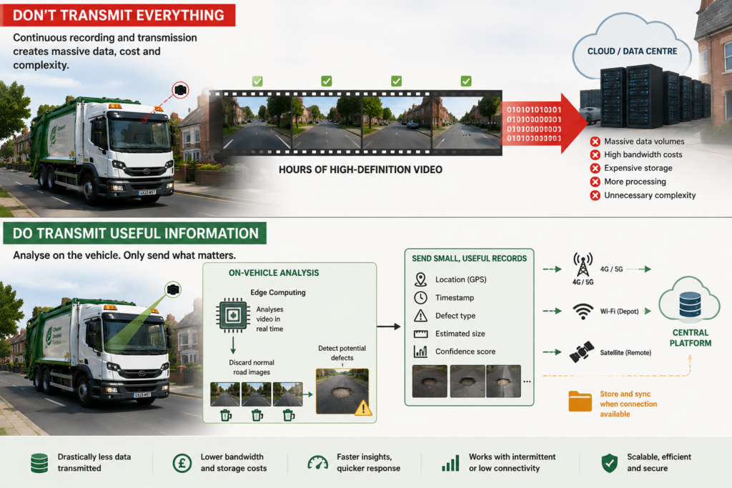
Instead of transmitting hours of continuous video, the vehicle would transmit relatively small defect records. A record might contain several images, a few seconds of video, the location of the observation, an initial classification and, where the imaging system supports it, estimated dimensions.
This also makes connectivity much less of a constraint. Vehicles operating in areas with reliable 4G or 5G coverage could send observations as they are generated. Where connectivity is poor, records could simply remain on the vehicle until a connection becomes available. Synchronisation could even take place over Wi-Fi when the vehicle returns to its depot. Satellite connectivity could provide another option for authorities operating across particularly remote areas, but continuous connectivity wouldn’t be fundamental to the design.
The important point is that the vehicle sends useful information rather than a constant stream of raw footage.
Measuring more than the existence of a pothole
Simply knowing that a pothole exists would already be useful, but the imaging system could potentially provide considerably more information.
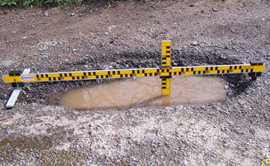
The approximate width, length and surface area of a defect can be estimated from appropriately calibrated imagery. Depth is more challenging because perspective, shadows, standing water and camera position can all affect the result. A more sophisticated installation could therefore use stereo cameras, known camera geometry, measurements across multiple frames or compact depth-sensing technology such as LiDAR.
This could produce a defect record containing the location, approximate dimensions, classification, images and confidence level. Rather than receiving a report stating that there is a pothole somewhere on a particular road, the highways team could receive a geolocated observation showing what the defect looks like and providing enough information to help determine whether it warrants further inspection.
The intention would not be to remove professional judgement from the process. Highway inspectors would remain essential, particularly where defects are difficult to assess visually or where intervention decisions require physical inspection. The benefit is that inspectors could have much better information about where they should direct their attention.
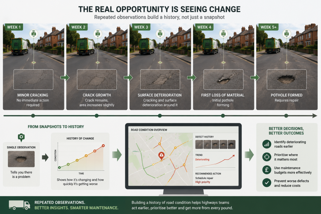
Pothole detection itself isn’t particularly revolutionary. Computer vision has been used to identify road defects for some time. The more interesting opportunity comes from repeatedly observing the same road.
Imagine a refuse vehicle travelling along a residential street each week. During one journey, the system identifies some surface cracking but nothing that appears to require immediate attention. The observation is recorded and associated with that section of road.
The following week, the road is observed again. The crack remains, but the affected area has increased slightly. Two weeks later there is evidence of surface deterioration around it. A subsequent journey shows the first loss of material, followed eventually by the formation of a pothole.
Taken individually, each observation is simply a photograph of a road defect. Taken together, they form a history of how that part of the road is changing.
This is where the approach becomes much more useful. Instead of simply asking whether a pothole exists, the system can begin to identify which parts of the network are deteriorating and how quickly that deterioration is taking place. A defect that has remained largely unchanged for several months may warrant a different response from one that has doubled in size over two weeks.
Over time, this information could help highways teams make better decisions about where limited maintenance resources should be directed.
Fixing the road before the pothole appears
There is also a potentially important economic difference between identifying a pothole quickly and identifying the conditions that are likely to produce one.
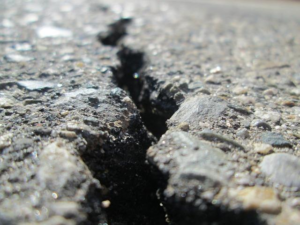
Once a road surface has failed and material has been lost, the authority has a defect to repair. Depending on its location and severity, it may also have an immediate safety issue to manage. Earlier intervention may be considerably simpler if deterioration can be identified while it is still at the stage of cracking, water ingress or localised surface failure.
This fits well with the wider move towards preventative highway maintenance. Rather than concentrating resources primarily on individual defects after they have reached intervention thresholds, better condition information can help authorities identify areas where earlier maintenance may prevent more extensive and expensive failure later.
It is important not to overstate what automated observation could achieve. A camera cannot see every structural issue developing beneath a road surface, and not every crack will become a pothole. However, increasing the amount of condition information available to the highways team provides another input into the decision-making process.
It also creates evidence. Instead of relying on occasional snapshots of network condition, an authority could gradually build a history showing how different sections of road change throughout the year.
Building a history of the highway network
Once observations are collected centrally, they can be compared with previous journeys and with information already held in highway asset management systems.
This correlation is important because the same defect may be seen by several vehicles, reported by a resident and subsequently inspected by a highways officer. A useful system should recognise that these are different observations of the same issue rather than creating multiple unrelated records.
The central platform could associate new observations with known defects, determine whether a repair has already been scheduled and highlight significant changes. If a pothole observed last week has become noticeably larger, that change may affect its priority. If the road has been repaired, the next vehicle passing the location could provide evidence of the completed work and allow its condition to continue being monitored.
After months or years of operation, the resulting dataset becomes much more interesting than a simple list of potholes. Each section of highway begins to develop a condition history. Authorities could see where cracking repeatedly occurs, where repairs fail sooner than expected, where standing water regularly appears and which parts of the network deteriorate most rapidly following winter weather.
That information could support maintenance planning as well as day-to-day defect management.
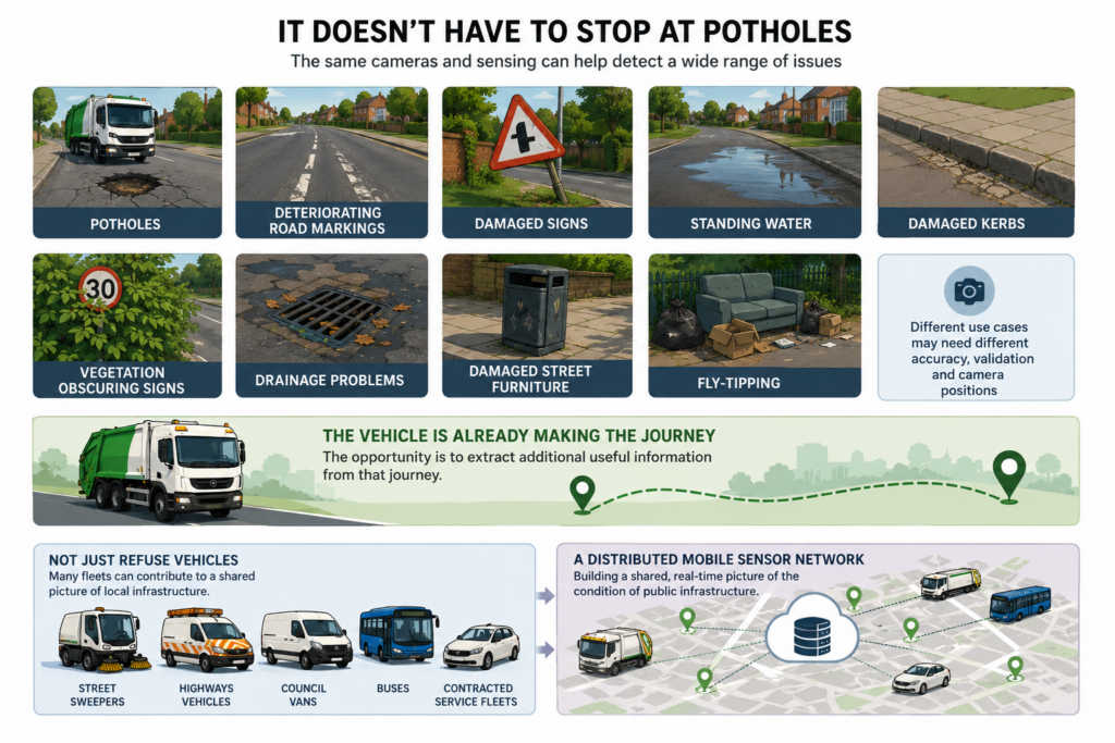
This is where the wider value of the idea becomes apparent. Once cameras, location data and computing capability are installed on vehicles regularly travelling through the authority’s area, potholes are only one of the things that can be observed.
The same imagery could potentially help identify deteriorating road markings, damaged signs, standing water, damaged kerbs, vegetation obscuring signs, drainage problems, damaged street furniture or fly-tipping. Different use cases would require different levels of accuracy, validation and potentially different camera positions, but the underlying principle remains the same.
The vehicle is already making the journey. The opportunity is to extract additional useful information from that journey.
Nor does the idea need to be limited to refuse vehicles. Street sweepers, highways vehicles, council vans, buses and contracted service fleets all repeatedly travel through local authority areas. Each could potentially contribute observations to a shared picture of the condition of public infrastructure.
Viewed this way, the refuse vehicle isn’t really becoming a pothole detector. It is becoming one component of a distributed mobile sensor network.
The business case needs to consider what councils already spend
There would obviously be a cost to implementing such a system. Cameras and edge-computing hardware need to be purchased and installed. Models need to be developed, tested and maintained. Connectivity, central infrastructure and integration with existing systems all need to be considered. There are also important requirements around cybersecurity, privacy, data retention and governance.
However, evaluating the idea purely on the cost of the technology risks missing the more important comparison.
The question isn’t simply how much an automated road-observation system costs. It is how much it would cost to achieve a comparable increase in observational coverage using conventional inspection methods.
If a residential road that would normally receive periodic formal inspections can additionally be observed 40 or 50 times per year because council vehicles already travel along it, the authority gains a much richer understanding of its condition without creating 40 or 50 additional dedicated inspection visits.
There are potential secondary benefits as well. Earlier detection may allow smaller repairs. Better information can improve prioritisation. Identifying defects before road users encounter them could reduce vehicle damage, complaints and potentially compensation claims. Better historical information may also improve decisions about resurfacing and longer-term maintenance programmes.
For taxpayers, the underlying proposition is straightforward: can a journey that is already being funded deliver more than one useful public outcome?
There are practical issues to solve
There are, of course, significant details that would need to be addressed before deploying this at scale.

Privacy is one. Cameras operating in residential areas will inevitably capture people, vehicles, number plates and parts of private property. The system would therefore require clear rules governing what is retained, how long it is stored and who can access it. Processing data on the vehicle and retaining only images associated with relevant highway observations could actually help reduce this exposure compared with continuously storing complete journeys.
Accuracy is another. Models would need to work across different road surfaces, weather conditions, lighting and seasons. Wet roads look different from dry roads. Shadows can resemble surface defects. Leaves and standing water can obscure them. False positives create unnecessary work, while false negatives risk providing misplaced confidence.
There are also questions around system integration and operational ownership. Many councils outsource elements of refuse collection or highway maintenance, which raises questions about who owns the equipment and data. Observations also need to flow into existing highways processes rather than creating yet another standalone dashboard for officers to monitor.
None of these issues are unusual for a technology project of this kind, but they do mean that the system should be treated as an operational highway capability rather than simply an interesting computer-vision experiment.
Start with a few vehicles and prove the value
A pilot wouldn’t require an entire refuse fleet to be equipped from day one. A small number of vehicles operating across representative routes could provide enough information to determine whether the concept has operational value.
The pilot should include different road types and conditions: residential estates, busy urban roads and, where appropriate, rural routes. It should operate across enough time to experience changing weather and lighting conditions.
Most importantly, success shouldn’t simply be measured by the number of potholes detected. The more useful questions would be whether the system identifies defects before they are reported through existing channels, how accurately it associates observations with locations, whether repeat journeys can reliably track deterioration and whether the resulting information helps highways teams make better decisions.
It would also be worth measuring how much raw data is processed on the vehicle compared with how much is actually transmitted. That would provide useful evidence for the cost and scalability of a wider deployment. The technology to recognise a pothole is only one part of the experiment. The real test is whether more frequent observation produces better outcomes.
From fixing potholes to understanding roads
The pothole problem is a useful example because almost everybody understands it. We have all driven around one, driven through one or seen a road surface gradually deteriorate until a repair becomes unavoidable.
But the wider opportunity is about how local authorities gather information about the physical environment they manage. Every day, councils and their contractors send vehicles throughout towns, cities and rural communities to provide services. Those journeys have traditionally had a single operational purpose. A refuse vehicle collects waste. A street sweeper cleans roads. A bus transports passengers.
Cameras, inexpensive computing and modern connectivity create the possibility of those journeys producing useful information at the same time. Importantly, processing at the edge means this doesn’t have to involve continuously recording communities or transmitting enormous quantities of video. The system can be designed to identify the relatively small number of observations that matter and discard the rest.
For highways teams, that could provide a layer of network visibility that sits between formal inspections and public reports. It doesn’t replace either. It fills some of the gaps between them. The result could be earlier identification of deterioration, better evidence for prioritising maintenance and a more complete understanding of how the road network changes over time.
Britain doesn’t necessarily need thousands of additional vehicles driving around looking for potholes. In many cases, the vehicles required to observe them are already travelling those roads every week. Perhaps the more useful question is what else those journeys could tell us.
The bin lorry will still empty the bins. But with a camera, some local processing and the right integration into existing highways systems, it could also help the council understand what is happening to the road beneath it. And spotting the pothole is useful.
Understanding that the road is beginning to fail before the pothole forms could be considerably more valuable.